Scope and Characteristics of Manila Bay
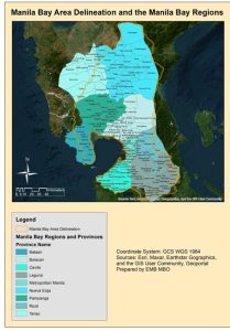
The Manila Bay Area covers the Manila Bay and its watershed area. It has a coastline of 190 km, from Mariveles Bataan stretching through Pampanga, Bulacan, and Metro Manila spanning to Ternate, Cavite. The Manila Bay area is bounded by the Caraballo Mountains and Zambales Mountains in the north, Sierra Madre Mountain Range in the east, and Mountains of Cavite and municipalities of Rizal in the south. Its drainage area covers 1,994 km2, or 199,400 hectares. Manila Bay is amongst the country’s most significant areas in terms of impact to economy and governance. It serves as a gateway for socio-economic development in the Country.
Why is Manila Bay Significant?